reminder from Elle: don't forget to put coins outside your door tonight and bring them back in first thing tomorrow, for prosperity in the new year.
additional insurance: we were on a lovely boat today, and the owner was putting coins on all the stairs to ensure good fortune. She said it was a Chinese custom. I can find nothing about this on line, but am testing it out here anyway.
Friday, December 31, 2010
Wednesday, December 29, 2010
N 24 41.782 W -81 07.068
19 miles, 3 hours
We got to Marathon yesterday and anchored in our usual spot: beside the sunken fishing boat just west of Vaca Key. And it is cold. Not to be all whiney about temps in the low 60's, but it is not what people here expect. A wonderfully sociable place, there are all sorts of lunches, happy hours, lectures, yoga classes, bingo games, etc. On New Year's Day, they've announced there will be a swim at noon, no matter what the water temperature! probably around 65 ...
Tuesday, December 28, 2010
from Key Largo to Channel Key, FL
N 24 47.283 W -80 54.989
36 miles, 8 hours
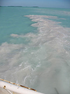
Here's our wake, probably composed of exquisite corals- no, not seriously. We did cut a swathe through Florida Bay, though. 6.5' draft, 7' channel. We forgot the Coast Guard rule: double the draft of your boat, and stay out of anything less.
Friday, December 24, 2010
Wednesday, December 22, 2010
Day 86
Typical Lincoln Road beauty. International tourists, dogs in strollers. Unwalkably high heels. The weekend is worth waiting for, but it's a show every night.
Tuesday, December 21, 2010
Sunday, December 19, 2010
Day 83-85
They do have quite a beach. It goes on for miles and miles- this is on South Beach near the hotels (each one has slightly different cabañas. It looks like fun). The main activity here is gathering on the streets to watch each other walk by. Fashion-watching, dog-watching, accent-eavesdropping, all top-notch.
Saturday, December 18, 2010
Friday, December 17, 2010
Day 81
N 26 00.551 W -80 07.197
53 miles, 8 hours
Out on the ocean most of the day yesterday- it was fairly calm. That's how we like the ocean: UNEVENTFUL. We came in at Fort Lauderdale, waited for a few bridges. Anchored in one of the keyholes off the ICW- kids water skiing around us.
Tuesday, December 14, 2010
Sunday, December 12, 2010
Day 77-78
N 26 50.141 W -80 03.146
29 miles, 4.5 hours
We must have crossed some magical divide- the water's suddenly a lovely turquoise and five degrees warmer. It's supposed to be windy and cold for a couple of days, then calm down toward the middle of the week. We think we'll stay anchored till we can continue on the outside, rather than visit the 30 legendary bridges south of Palm Beach.
houses along the ICW
Friday, December 10, 2010
Day 76
N 27 14.921 W -80 13.195
29 miles, 4.5 hours
Cops boarded our boat! It was very exciting. We were coming back from dinner in the dinghy, and as we passed under a bridge, a woman yelled at us to stop. Of course I assumed it was a crazy person, and kept going. But no, it was a cop, and she did not approve of us running the boat without lights. In fact, we were running without a red, a green and a white light! So now we have a couple of tickets from whatever county this is, and have sworn never go out to dinner with a flashlight again. Except in Marathon- it always seemed to work ok in Marathon. And RI, and NYC, and Provincetown. Oh well.
Day 75
N 27 43.142 W -80 23.832
49 miles, 7.5 hours
Abby called- her stepbrothers live in Cocoa, so she was just there last month.
We're lounging around this morning until the fog lifts. Lorenzo's asking other cruisers for advice on the stretch between Palm Beach and Miami. There are so many low bridges, and so little room in some spots, that it has attained quite a reputation among boaters.
Wednesday, December 8, 2010
Day 74
from Daytona Beach to Cocoa, FL
N 28 27.867 W -80 45.178
50 miles, 9 hours
To the west of Cape Canaveral. We actually saw something launch -just a pink streak, but can't find it on the NASA site. Maybe someone will inform us. The rest of the day involved a lot of waiting at bridges.
N 28 27.867 W -80 45.178
50 miles, 9 hours
To the west of Cape Canaveral. We actually saw something launch -just a pink streak, but can't find it on the NASA site. Maybe someone will inform us. The rest of the day involved a lot of waiting at bridges.
Tuesday, December 7, 2010
Day 73
from St. Augustine to Daytona Beach, FL
N 29 11.665 W -81 00.112
47 miles, 8 hours
We're just leaving St. Augustine, and noticed the May 21st girls sitting on the wall below the fort watching the sun rise.
Monday, December 6, 2010
Day 71-72
N 29 53.892 W -81 18.536
15 miles, 2 hours
We got here yesterday morning, and decided to move faster- it's going through a real cold snap.
Night temp in the 30's. Water temp: unknown.
Day 70
N 30 03.066 W -81 21.941
48 miles, 8 hours
Very few anchorages hereabouts. This is an oxbow creek just north of St. Augustine.
Thursday, December 2, 2010
Wednesday, December 1, 2010
Day 67-68
N 30 55.865 W -81 26.866
24 miles, 4 hours
The north end of Cumberland Island is pretty nice; there's a tiny church, but not much else. Pine forest and armadillos. We were the only people.
A ferry goes to the south end, so there are day visitors as well as campers in the few coveted sites. Spectacular beach on the ocean side.
more pix
Saturday, November 27, 2010
Day 65-66
N 31 09.741 W -81 25.191
28 miles, 4 hours
It's difficult to post pictures with the connection here, so these are the high points of St. Simons:
-small airport right on the main road, where you can watch the takeoffs and landings of locals with their own planes
-quirky used bookstore
-great barbecue place
-municipal landscaping: the entire island is groomed.
Elle says Sea Island- the ocean side- even dictates the color of flowers you're allowed to plant- sorry to miss that!
Wednesday, November 24, 2010
Day 62-64
Murals in the Circus Room at RJ Reynolds' mansion-
from Ossabaw Island to Sapelo Island, GA
N 31 26.391 W -81 17.537
32 miles, 5 hours
We're stuck here in the Georgia sea islands- too beautiful to leave. We think we'll stay at Cumberland Island for a few days- that's the last one- and then head out along Florida to Key West. Today we join a tour of Sapelo Island, as that is the only way to visit. There are some residents grandfathered in here, but no tourists. Most of it is saltmarsh. A lot of these islands are off limits to the (human) public, which makes them all the more beautiful.
The tour took us to the only town on the island, Hog Hammock. People still living here full time (about 50) are descended from slaves. Kids take the ferry to school in Darien, and the people left here are mostly older ones. They work for the state of Georgia and rent out rooms to tourists.
Sapelo was owned by a series of tycoons, the last of whom was R.J. Reynolds. We roamed around his mansion, which you can rent out for house parties- many bedrooms. Fabulous decor, last updated in the 50's.
On Thansgiving morning, one of the local kids took us around on a private tour. So we saw historic buildings/ ruins, beaches, and favorite hunting spots. These guys love to hunt! Here they have wild cows, raccoons, possum, and the occasional coyote. All were on the menu at his grandma's that day, except the coyote. When we said we were having lamb, he was really interested- 'Yeah? what's that taste like?'
Sunday, November 21, 2010
Day 59-61
N 31 45.824 W -81 08.739
20 miles, 3 hours
Ossabaw is one of the Sea Islands, a large one. It seems to be inhabited by wild birds, deer, and pigs, and is absolutely beautiful.
We went ashore again this morning intending to take pictures of all the fun stuff we saw roaming around yesterday, but all we saw were a tribe of black pigs fleeing into the underbrush- little ones- they looked like Scotties.
Friday, November 19, 2010
Tuesday, November 16, 2010
Day 55
from Dawho River to Beaufort, SC
N 32 25.424 W -80 39.956
32 miles, 5 hours
We were stuck in the mud here for an hour and a half today, and I feel I know every grass tuft personally. The plan was to anchor well away from other boats, but we got mired in mud. and the wind kept blowing us up onto the shore. Lorenzo finally worked the boat out. The usual thanks to all Muzz's favorite saints who were pressed into duty.
Monday, November 15, 2010
Day 53
N 32 53.478 W -79 41.861
39 miles, 6 hours
Anchored last night in the salt marshes. Deluxe place. Swam in salt water! Had Verizon reception! This is just north of Charleston, so today we'll pass through there and see what's on the other side.
Saturday, November 13, 2010
Day 52
N 33 21.530 W -79 16.872
25 miles, 4 hours
A town with groceries! we bought: lettuce, collards, cabbage, potatoes, onions, apples, and tangerines.
Day 51
Thursday, November 11, 2010
Tuesday, November 9, 2010
Day 48
N 34 03.127 W -77 53.265
27 miles, 5.5 hours
We're in line behind three sailboats at this bridge, one of two today. The ICW is very slow. On the upside, you see things like this:
Monday, November 8, 2010
Day 47
from Bogue Sound to Topsail Sound, NC
N 34 24.479 W -77 35.658
42 miles, 7.5 hours
Not the typical house along the ICW, but certainly a standout.
Sunday, November 7, 2010
Day 45-46
Saturday 11/6
from Beaufort to Cape Lookout, NC
N 34 37.214 W -76 32.948
11 miles, 2 hours
Sunday 11/7
from Beaufort to Cape Lookout, NC
N 34 37.214 W -76 32.948
11 miles, 2 hours
Sunday 11/7
from Cape Lookout to Bogue Sound, NC
N 34 43.227 W -76 53.794
21 miles, 3.5 hours
N 34 43.227 W -76 53.794
21 miles, 3.5 hours
This is the harbor outside Beaufort- we wouldn't fit inside easily. As it was, our anchor dragged, and we added another 100 feet of chain to it- that seems to have done the trick. Saturday we came down to Cape Lookout, a beautiful beach- BUT COLD! The wetsuit thing is good, though- water seems warmer than the air. Credit to the Felix the catamaran for the pix.
Saturday, November 6, 2010
Day 41-44
Beaufort, NC
where's this guy going? we're thinking one of the fishermen got sick of sitting out there in the cold, and sent for some home comforts. still not sure what they're fishing for- flounder, bass, trout are all abundant. They're out there in all sorts of weather- in open boats- in waders, even.
Subscribe to:
Comments (Atom)


